Terminology used to describe the various elements of a street network:
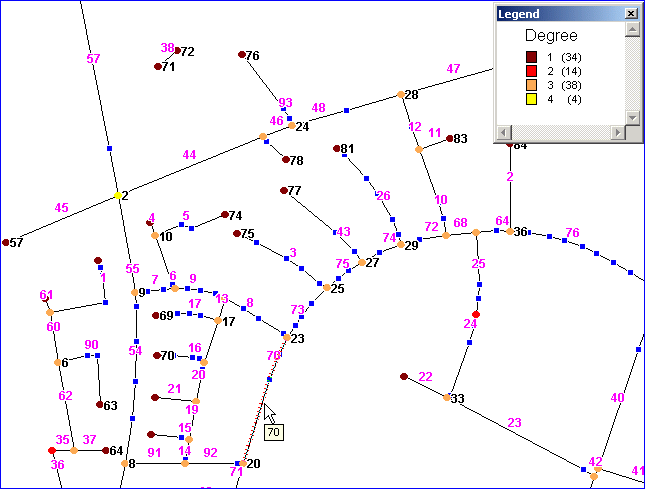
A link consists of several connected vertices (2 or more, blue squares on the map below). The first vertex of a link is called the from-node and the last vertex is called the to-node. See function Link2FromNode and Link2ToNode.
Most of the nodes share coordinates with nodes of other links. The number of links sharing a node is referred to as the degree of the node. You should normally never reach more than 10. See function Degree.
A node is also called an intersection - even if the degree is 1 or 2. A link where one of the nodes has degree 1 is called a dangling link. A node with degree 2 is called a pseudo-node (see function Join). The red node on the map is such a pseudo-node.
A link is identified by it's internal ID (Magenta text on the map: 1, 2, 3 ....), which corresponds to the record ID's of the input dataset used by function TImport.execute.
A node is identified by it's ID (Black text on the map: 1, 2, 3 ....). Node ID's are primarily ordered by degree in descending order and secondarily by x-coordinate in ascending order. Node ID's are assigned during network import and can not be controlled by the user.
A location is a position on a link: e.g. 50% along link 70 - counted in the same direction as that the link has been digitized in. This appr. matches the cursor on the map below. Locations are used when doing dynamic routing. The percentage needs to be between 0 and 1 (both included).